Loving the Library of Congress Online
Loving the Library of Congress Online
Whoa, it’s hard coming up for air to write this story. I have been immersed the past couple of hours in the Library of Congress website. It’s the Fourth of July and I found that to be an appropriate way to honor our nation’s birthday. So much is happening in Washington DC today – actually these days – that I thought I’d take a quick trip there to soak up more of our nation’s history.
As I wrote in my previous post, “Loving the Library of Congress“, this bastion of world history and culture ranks as a top place to visit. But know that you can have almost as much fun taking in the treasure trove of pieces from the vast collection of this renowned American institution online.
Not surprisingly, here I’m focusing on the map department of the Library of Congress, however, there’s much more published material such as books, prints, photographs, manuscripts, legal documents and tons more that you can also find online. Just like the actual Library of Congress, you could spend months digging through their archives and still not unearth it all. (Keep in mind, too, that librarians stand–or perhaps sit–at the ready to answer your every query.) Did you also know every map from Discovery Map destinations are sent to the Library of Congress every year? Pretty cool stuff!
I suggest you start out by clicking on their Maps page, type what interests you into the search and blast off. Most of the maps are old (sorry, no new Discovery Maps on this page), which makes the hunt all the more exciting for history buffs.
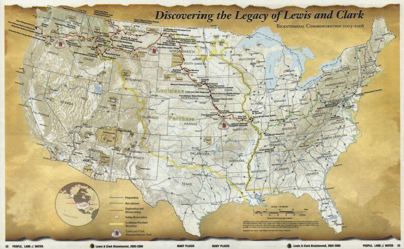
I zeroed in on a map entitled Discovering the legacy of Lewis and Clark: bicentennial commemoration 2003-2006. Very cool. Notes are provided indicating that the map furnishes historical and descriptive text about the expedition and this historic trail. Other information such as the language (English, in this case), location, dates, size and contributors, one of which was William Clark, is also highlighted. But what is super cool is the zoom in/zoom out feature. And you thought Google Maps was good? The entry also lists other maps similar to the one highlighted as well as complementary books. This is definitely a great place to hang if you’re a map geek like me.
What’s unbelievable is that you can actually download jpegs of these maps. Their rights section states that the Library of Congress is providing access to these materials for educational and research purposes and is not aware of any U.S. copyright protection, since their Map Collections materials were either published prior to 1922, produced by the United States government, or both. So let’s just say that you wouldn’t want to use these maps as the background of a movie poster without obtaining proper permission but it seems OK to print them out to hang on your wall. As always, use your best judgement and verify when in doubt.
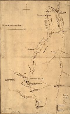
Here’s a rather unusual find:I typed Lake George, New York into the search because I know that Discovery Map’s owner, Peter Hans, vacationed there as a kid. I was disappointed to find that the Library of Congress only features eight maps of this “Queen of American Lakes” online but I found one to be a real gem. It’s the Plan of the attack on Fort William Henry and Ticonderoga; showing the road from Fort Edward, Montcalm’s camp and wharf of landing, & c. It looks like it was scribbled onto a parchment–pen-and-ink on manuscript to be exact. Dating from approximately 1757, it’s no wonder this one is kept in the vault! It serves as living proof of the rich history that transpired on this Adirondack lake during the American Revolution. I zoomed in to recognize the notation of Northwest Bay on the lake and the Hudson River to the south. Excuse me, if I’m sounding too much like a map geek. But I love this stuff!
Check out the Collections with Maps that include Railroad Maps from 1828-1900, all kinds of Panoramic Maps, Mapping the National Parks–you name it!
You can also subscribe to the Library of Congress Map Division blog. A recent post featured the following: Map Helps Uncover Civil War Battlefield Tunnels at Petersburg, Virginia. Is that map geeky enough for you?
Thank you to the Library of Congress, Geography and Map Division, for the images featured within this post.
")
